Garmin 2009 Annual Report Download - page 12
Download and view the complete annual report
Please find page 12 of the 2009 Garmin annual report below. You can navigate through the pages in the report by either clicking on the pages listed below, or by using the keyword search tool below to find specific information within the annual report.-
 1
1 -
 2
2 -
 3
3 -
 4
4 -
 5
5 -
 6
6 -
 7
7 -
 8
8 -
 9
9 -
 10
10 -
 11
11 -
 12
12 -
 13
13 -
 14
14 -
 15
15 -
 16
16 -
 17
17 -
 18
18 -
 19
19 -
 20
20 -
 21
21 -
 22
22 -
23
-
24
-
25
-
26
-
27
-
28
-
29
-
30
-
31
-
32
-
33
-
34
-
35
-
36
-
37
-
38
-
39
-
40
-
41
-
42
-
43
-
44
-
45
-
46
-
47
-
48
-
49
-
50
-
51
-
52
-
53
-
54
-
55
-
56
-
57
-
58
-
59
-
60
-
61
-
62
-
63
-
64
-
65
-
66
-
67
-
68
-
69
-
70
-
71
-
72
-
73
-
74
-
75
-
76
-
77
-
78
-
79
-
80
-
81
-
82
-
83
-
84
-
85
-
86
-
87
-
88
-
89
-
90
-
91
-
92
-
93
-
94
-
95
-
96
-
97
-
98
-
99
-
100
-
101
-
102
-
103
-
104
-
105
-
106
-
107
-
108
-
109
-
110
-
111
-
112
-
113
-
114
-
115
-
116
-
117
-
118
-
119
-
120
-
121
-
122
-
123
-
124
-
125
-
126
-
127
-
128
-
129
-
130
 |
 |

10
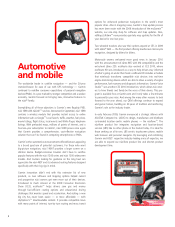
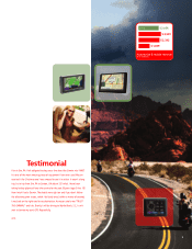
Versatility was the theme for 2009 in Garmin’s outdoor recreation
and fitness product lines. From do-it-all touchscreen outdoor hand-
helds to wireless workout wonders, customers turned to Garmin’s
innovative devices in an economy where budget-friendly activities
focused on family adventures and personal wellness.
Leading the way for Garmin’s multipurpose handhelds is the Oregon®
550t, featuring a digital camera, preloaded topographic maps and
the popular touchscreen interface of the Oregon family. With the
550t, hikers and hunters now have a rugged, waterproof camera and
easy-to-read topographic maps at their fingertips, with automatically
geotagged photos that remind them of where they’ve been and
what they’ve done. For those who want a smaller device, Garmin
introduced the Dakota® series, ideal for family fun and geocaching.
And because the Oregon and Dakota products are also compatible
with optional street mapping and marine charts, customers have
simple solutions for navigating on the trail, on the water and on
the road. Garmin’s already expansive mapping options for outdoor
handhelds also grew in 2009, with free utilities such as Custom Maps
and Garmin Connect™ compatibility. Through a few simple steps,
Garmin’s Custom Maps can bring the details, labels and landmarks
of an existing paper or electronic map to compatible products such as
Oregon, Dakota or Colorado®. And experiences will live on at Garmin
Connect, the free-to-join online community of more than 17 million
activities for sharing and storing.
Outdoor
and fitness