Pioneer 2015 Annual Report Download - page 8
Download and view the complete annual report
Please find page 8 of the 2015 Pioneer annual report below. You can navigate through the pages in the report by either clicking on the pages listed below, or by using the keyword search tool below to find specific information within the annual report.-
 1
1 -
 2
2 -
 3
3 -
 4
4 -
 5
5 -
 6
6 -
 7
7 -
 8
8 -
 9
9 -
 10
10 -
 11
11 -
 12
12 -
 13
13 -
 14
14 -
 15
15 -
 16
16 -
 17
17 -
 18
18 -
 19
19 -
20
-
21
-
22
-
23
-
24
-
25
-
26
-
27
-
28
-
29
-
30
-
31
-
32
 |
 |

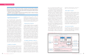
Research and Development
By providing new value derived from its core technologies, Pioneer aims to achieve a rich, mobile
society in which everyone using roads can move safely, reliably, and comfortably.
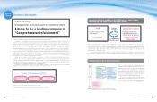
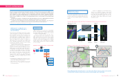
Precisely locating a vehicle’s position using 3D point cloud map data and images from a vehicle-mounted camera
Highly precise vehicle location image using SLAM technologies
Optical
system Scanner
Transmitter
Receiver
Signal processing
Spatial processing
Creation of
map data
Recognition of
object information
LiDAR
Laser beam
Object
Measurement of
vehicle’s location
SLAM technologies have greater accuracy than GPS
LiDAR system creates 3D point
cloud map data Road outline map is created
Latitude and
longitude
Binary
conversion
Projective
transformation
Camera image Image processing,
vehicle location
A
A
B
SLAM
GPS
Algorithm for using a LiDAR system to recognize an object
B
Pioneer’s research and development anticipates the future of the Car Electronics business. In addition to our
traditional strengths in optics, signal processing, information processing, and systematization through applying
such capabilities as device development, we are developing technologies related to hardware, map data,
Smart Loop,*1 and augmented reality (AR) that can overlay information on actual surroundings. Through these
efforts, we will contribute to the creation of new digital infrastructures for a truly mobile society while growing
our business.
We are also proactively conducting research and development in the areas of OLED lighting and medical
and health care-related devices, which we are cultivating as potential new core businesses.
In addition, we are undertaking joint research with universities, public research institutions, and other private
companies, in the pursuit of realizing innovation and accelerated research and development.
*1 Smart Loop: Pioneer’s proprietary information network service for hardware
LiDAR systems are core systems for creating highly
precise, next-generation map data, and show future
potential as indispensable sensing systems for spatial
recognition in automated driving.
Pioneer is using its optical technologies devel-
oped through optical disc technologies, its wide
band analog circuitry technologies, and its digital
signal processing technologies to research and de-
velop basic technologies and applications for LiDAR
systems, with the aim of achieving low-cost, highly
reliable LiDAR systems that are compact and suited
for use in vehicles.
LiDAR Systems*2 and High-Precision
Location Technologies for the Age of
Automated Driving
Pioneer has been offering new value for the creation
of rich car lifestyles, focusing on car AV products
and car navigation systems. Recent years have seen
major advances in the development of hardware for
safety and reliability, a leading example of which are
pre-crash safety systems that avoid collisions or
reduce the damage from collisions. In response to
expectations for an even safer, more reliable, and
more comfortable “automobile society” in the future,
we have been working in a variety of areas focusing
on automated driving technologies.
Specific areas in which we are developing include
highly precise location technologies which are es-
sential for automated driving in guiding the vehicle;
highly precise next-generation map data which is
an underlying technology that makes it possible to
recognize the surrounding environment; information
processing technologies that control how the hard-
ware handles the map data; sensing technologies
that accurately recognize the surrounding envi-
ronment as the vehicle is being driven; and signal
processing technologies including image processing
and SLAM.*3
*2 LiDAR (Light Detection and Ranging) systems: Systems that use a laser to
receive scattered light from surrounding objects to measure the distance
from those objects and analyze their shape and features
*3 SLAM (Simultaneous Localization and Mapping): Technologies that
simultaneously localize the current position and create map data for
the surrounding environment
Pioneer is applying the technologies devel-
oped in its car navigation systems to develop 3D
sensing technologies using LiDAR systems, highly
precise map data, and SLAM technologies, to locate
a vehicle’s position with a margin of error in the
10-centimeter range, which is much more accurate
than GPS systems.
The creation of data that precisely locates a vehicle’s
position in real time is an extremely important tech-
nology in the research and development of automated
driving.
LiDAR Systems
Highly Precise Vehicle
Location Technologies
12 Pioneer Corporation Annual Report 2015 13
Pioneer Corporation Annual Report 2015